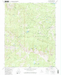
1982 Map of Mt. Givens
USGS Topo · Published 1987About this map
The South Fork San Joaquin River and the high peaks of the Sierra National Forest define this landscape in the early 1980s. A focal point for seasonal activity is Mono Hot Springs, situated near the confluence of Mono Creek and the river. This area serves as a significant gateway for recreation and forest management, anchored by the High Sierra Ranger Station and various camps such as China Camp and Weldons Camp. The high-altitude terrain is marked by prominent summits like Mt. Givens and Mount Ian Campbell, alongside specialized infrastructure like the Radio Facility and the Portal Forebay. Tracing the winding Kaiser Pass Road reveals the remote connectivity of the Kaiser Wilderness, where small alpine water bodies like Corbett Lake and Cunningham Lake dot the granite basins.
Find a feature on this map
52 named features on this map. Tap any name to fly to it.
Don’t see what you’re looking for? This feature index may not catch every label — zoom into the map to look around manually.
Map Details
Editions of this 1982 Mt. Givens Map
3 editions found
Other maps of this area

1904 · Kaiser
USGS Topo · 1:125,000

1912 · Mt. Goddard
USGS Topo · 1:125,000

1947 · Mariposa
USGS Topo · 1:250,000

1948 · Mariposa
USGS Topo · 1:250,000

1953 · Mt Abbot
USGS Topo · 1:62,500

1953 · Huntington Lake
USGS Topo · 1:62,500

1953 · Blackcap Mtn
USGS Topo · 1:62,500

1953 · Kaiser Peak
USGS Topo · 1:62,500

1957 · Mariposa
USGS Topo · 1:250,000
1962 · Blackcap Mtn
USGS Topo · 1:62,500