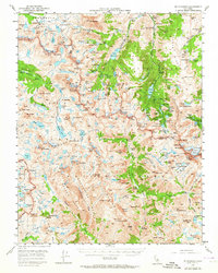
1957 Map of Mt. Goddard
USGS Topo · Published 1964About this map
The high Sierra crest at the intersection of Inyo and Fresno counties appears here just as high-altitude recreation and mining were beginning to overlap in the mid-20th century. The Eastern Sierra slope is marked by early industrial activity, including the Cardinal Mine and the Salty Peterson Mine, alongside early campsites like Parcher Camp. Water management is evident through the North Fork Bishop Creek and reservoirs such as Lake Sabrina and North Lake, which serve as gateways to the high country. West of the divide, the landscape opens into the expansive Humphreys Basin and the iconic Evolution Valley. This map captures the established route of the John Muir Trail through McClure Meadow and over the rugged passes, documenting the terrain before later wilderness designations further restricted development in these granite reaches.
Find a feature on this map
185 named features on this map. Tap any name to fly to it.
Don’t see what you’re looking for? This feature index may not catch every label — zoom into the map to look around manually.
Map Details
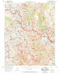
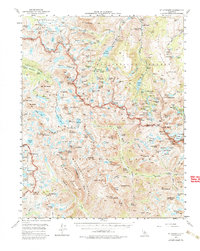
Editions of this 1957 Mt. Goddard Map
3 editions found
Other maps of this area

1903 · Tehipite
USGS Topo · 1:125,000

1905 · Tehipite
USGS Topo · 1:125,000

1907 · Mt. Whitney
USGS Topo · 1:125,000

1912 · Mt. Goddard
USGS Topo · 1:125,000

1913 · Bishop
USGS Topo · 1:125,000

1919 · Mt. Whitney
USGS Topo · 1:125,000

1937 · Mt. Whitney
USGS Topo · 1:125,000

1947 · Mariposa
USGS Topo · 1:250,000

1948 · Fresno
USGS Topo · 1:250,000

1948 · Mariposa
USGS Topo · 1:250,000