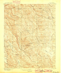
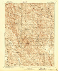
1897 Map of Mt. Hamilton
USGS Topo · Published 1901About this map
Lick Observatory stands as the primary landmark of this high-elevation terrain, perched atop the peaks of the Diablo Range at the close of the nineteenth century. The map illustrates a complex network of ridges including Valpe Ridge, Eylar Mountain, and Poverty Ridge, separated by deep drainage basins like Isabel Valley. The presence of the Hotel and Mowry Camp suggests early tourism and seasonal activity centered around the scientific outpost and the surrounding mountain landscape. Lower elevations to the west transition into the Halls Valley and the Canada De Pala land grant areas, where names like Masters Hill and Panochita Hill mark the local topography. This document preserves the late-1800s character of the wilderness before the expansion of modern infrastructure into the mountains east of the Santa Clara Valley.
Find a feature on this map
61 named features on this map. Tap any name to fly to it.
Don’t see what you’re looking for? This feature index may not catch every label — zoom into the map to look around manually.
Map Details
Editions of this 1897 Mt. Hamilton Map
6 editions found
Other maps of this area

1889 · San Jose
USGS Topo · 1:62,500

1897 · San Jose
USGS Topo · 1:62,500

1897 · Mt. Hamilton
USGS Topo · 1:62,500

1899 · San Jose
USGS Topo · 1:62,500

1906 · Pleasanton
USGS Topo · 1:62,500

1907 · Tesla
USGS Topo · 1:62,500

1916 · New Almaden
USGS Topo · 1:48,000

1917 · Morgan Hill
USGS Topo · 1:62,500

1919 · New Almaden
USGS Topo · 1:62,500

1921 · Gilroy Hot Springs
USGS Topo · 1:62,500