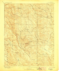
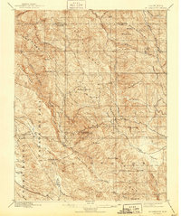
1897 Map of Mt. Hamilton
USGS Topo · Published 1906About this map
Lick Observatory crowns the summit of Mt. Hamilton, anchoring a landscape of complex ridge systems and secluded valleys at the turn of the century. This survey, conducted by R. B. Marshall, captures the Diablo Range during a period when the mountainous interior of Santa Clara and Alameda counties remained largely undeveloped, characterized by cattle ranching and early scientific exploration. Travel through this terrain relied on a network of winding roads and trails connecting points like the Hotel and remote outposts such as Mowry Camp. The map details a rugged topography defined by Oak Ridge, Valpe Ridge, and Mason Ridge, with deep drainages like Arroyo Mocho and Smith Creek carving through the slopes. Local landmarks like Ingram Flat and Blackbird Valley reflect the small-scale human footprint within the broad expanse of Isabel Valley and San Felipe Valley.
Find a feature on this map
62 named features on this map. Tap any name to fly to it.
Don’t see what you’re looking for? This feature index may not catch every label — zoom into the map to look around manually.
Map Details
Editions of this 1897 Mt. Hamilton Map
6 editions found
Other maps of this area

1889 · San Jose
USGS Topo · 1:62,500

1897 · San Jose
USGS Topo · 1:62,500

1897 · Mt. Hamilton
USGS Topo · 1:62,500

1899 · San Jose
USGS Topo · 1:62,500

1906 · Pleasanton
USGS Topo · 1:62,500

1907 · Tesla
USGS Topo · 1:62,500

1916 · New Almaden
USGS Topo · 1:48,000

1917 · Morgan Hill
USGS Topo · 1:62,500

1919 · New Almaden
USGS Topo · 1:62,500

1921 · Gilroy Hot Springs
USGS Topo · 1:62,500