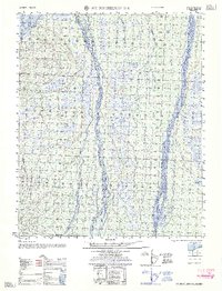
1962 Map of Mt. Michelson D-1
USGS Topo · Published 1962About this map
Braided river systems and the Arctic coastline of Camden Bay define this 1950s survey of the Alaska North Slope. The drainage pattern of the Hulahula River and the Jago River reveals the complex, shifting gravel bars of the tundra, where multiple channels diverge and rejoin across a landscape shaped by permafrost and seasonal thaw. Smaller waterways like Katakturuk River and Carter Creek feed into the northern coastal plain, providing a detailed record of the hydrography before modern industrial changes in the region. Compiled by the Army Map Service using photogrammetric methods from 1958, the map preserves the natural state of this remote environment, including soundings and coastal data along the Beaufort Sea as charted in the mid-1950s.
Find a feature on this map
7 named features on this map. Tap any name to fly to it.
Don’t see what you’re looking for? This feature index may not catch every label — zoom into the map to look around manually.
Map Details
Editions of this 1962 Mt. Michelson D-1 Map
This is the sole edition of this map. No revisions or reprints were ever made.
Other maps of this area

1951 · Barter Island
USGS Topo · 1:250,000

1951 · Demarcation Point
USGS Topo · 1:250,000

1951 · Mt. Michelson
USGS Topo · 1:250,000

1955 · Flaxman Island
USGS Topo · 1:250,000

1955 · Demarcation Point
USGS Topo · 1:250,000

1955 · Mount Michelson C-1
USGS Topo · 1:63,360

1955 · Demarcation Point C-5
USGS Topo · 1:63,360

1955 · Mount Michelson C-2
USGS Topo · 1:63,360

1955 · Flaxman Island A-1
USGS Topo · 1:63,360

1955 · Mount Michelson D-2
USGS Topo · 1:63,360