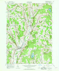
1943 Map of Mt Vision
USGS Topo · Published 1969About this map
Otego Creek carves a central path through the hills of central Otsego County, anchoring a landscape defined by small valley settlements and upland family farms in the early 1940s. The village of Mt Vision sits at the junction of several local routes, while Laurens occupies the southwestern corridor where Wharton Creek meets the main valley. This survey captures a rural New York educational system still operating through decentralized rural schoolhouses, including School No 5 and School No 13, many of which were later consolidated or closed. Local heritage is preserved in the numerous family and community burial grounds scattered across the townships, such as Babcock Cem and Tiffany Cem. On the western edge of the sheet, the established grounds of Gilbert Lake State Park provide a dedicated recreational space amidst the private timberlands and pastures that dominate the surrounding topography of Bunn Hill and Keyes Hill.
Find a feature on this map
39 named features on this map. Tap any name to fly to it.
Don’t see what you’re looking for? This feature index may not catch every label — zoom into the map to look around manually.
Map Details
Editions of this 1943 Mt Vision Map
5 editions found
Other maps of this area

1907 · Cooperstown
USGS Topo · 1:62,500

1909 · Cooperstown
USGS Topo · 1:62,500

1909 · Delhi
USGS Topo · 1:62,500

1910 · Hartwick
USGS Topo · 1:62,500

1911 · Delhi
USGS Topo · 1:62,500

1912 · Hartwick
USGS Topo · 1:62,500

1915 · Oneonta
USGS Topo · 1:62,500

1918 · Oneonta
USGS Topo · 1:62,500

1943 · Mt Vision
USGS Topo · 1:24,000

1943 · Milford
USGS Topo · 1:24,000