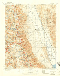
1937 Map of Mt. Whitney
USGS Topo · Published 1959About this map
Independence and Lone Pine anchor the Owens Valley on this 1937 revision, serving as the primary gateways to the high peaks of the Sierra Nevada. The valley floor is defined by the Southern Pacific Railroad and the historical site of Old Camp Independence, while the mountains are divided between Kings Canyon National Park and Sequoia National Park. High-altitude features like Tulainyo Lake and Whitney Portal illustrate the complex geography of the Inyo and Tulare county lines. This map details the transition from the arid valley floor, including the settlement of Manzanar, to the high water sources of the Kern River and South Fork Kings River. The presence of the Bluebell Mine in the Inyo National Forest highlights the diverse land use, from extraction to conservation, that shaped the region during the late 1930s.
Find a feature on this map
160 named features on this map. Tap any name to fly to it.
Don’t see what you’re looking for? This feature index may not catch every label — zoom into the map to look around manually.
Map Details
Editions of this 1937 Mt. Whitney Map
3 editions found

Other maps of this area

1903 · Tehipite
USGS Topo · 1:125,000

1904 · Kaweah
USGS Topo · 1:125,000

1905 · Tehipite
USGS Topo · 1:125,000

1905 · Olancha
USGS Topo · 1:125,000

1907 · Olancha
USGS Topo · 1:125,000

1907 · Mt. Whitney
USGS Topo · 1:125,000

1908 · Lida
USGS Topo · 1:250,000

1908 · Ballarat
USGS Topo · 1:250,000

1909 · Kaweah
USGS Topo · 1:125,000

1912 · Mt. Goddard
USGS Topo · 1:125,000