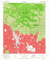
1966 Map of Mt. Wilson
USGS Topo · Published 1967About this map
Mount Wilson Observatory stands prominently atop the peaks of the Angeles National Forest, overlooking a rapidly expanding mid-century suburban corridor. This era in the San Gabriel Valley is defined by dense residential development pressing against the steep mountain front, where the corporate boundaries of Pasadena, Sierra Madre, and Arcadia converge. The landscape reveals a transition from the scientific and recreational heights of Mt Wilson and the historic Mt Lowe Railway to the civic infrastructure of the valley floor.
Find a feature on this map
98 named features on this map. Tap any name to fly to it.
Don’t see what you’re looking for? This feature index may not catch every label — zoom into the map to look around manually.
Map Details
Editions of this 1966 Mt. Wilson Map
4 editions found
Other maps of this area

1894 · Los Angeles
USGS Topo · 1:62,500

1894 · Pomona
USGS Topo · 1:62,500

1896 · Pasadena
USGS Topo · 1:62,500

1897 · Pomona
USGS Topo · 1:62,500

1898 · Pomona
USGS Topo · 1:62,500

1900 · Pasadena
USGS Topo · 1:62,500

1900 · Tujunga
USGS Topo · 1:62,500

1900 · Los Angeles
USGS Topo · 1:62,500

1901 · Southern California Sheet No. 1
USGS Topo · 1:250,000

1903 · Rock Creek
USGS Topo · 1:62,500