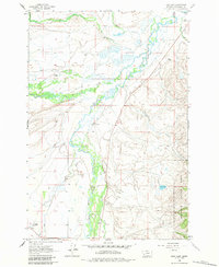
1962 Map of Mud Lake
USGS Topo · Published 1984About this map
The Big Hole River winds through this high-elevation landscape in Beaverhead County, defining a broad valley shaped by the confluence of the North Fork, Howell Creek, and Plimpton Creek. In the early 1960s, this area remained largely defined by traditional ranching and homesteading, evidenced by family-named sites like the Spokane Ranch, Daniels Ranch, and the Mussigbrod Homestead. The presence of the Wisdom Cem and the Mc Vey Homestead suggests the enduring ties of local families to this stretch of Montana. Towards the east, the terrain rises into the Beaverhead National Forest, where Mc Vey Creek and Doolittle Creek drain towards the valley floor. Near the southern edge of the forest boundary, Mud Lake sits amidst a network of smaller streams and marshes, illustrating the high-mountain drainage patterns of the region before modern development altered the rural character.
Find a feature on this map
19 named features on this map. Tap any name to fly to it.
Don’t see what you’re looking for? This feature index may not catch every label — zoom into the map to look around manually.
Map Details
Editions of this 1962 Mud Lake Map
3 editions found
Other maps of this area

1955 · Dillon
USGS Topo · 1:250,000

1957 · Dillon
USGS Topo · 1:250,000

1958 · Dillon
USGS Topo · 1:250,000

1962 · Dillon
USGS Topo · 1:250,000

1962 · Wisdom
USGS Topo · 1:24,000

1962 · Mud Lake
USGS Topo · 1:24,000

1962 · Pine Hill
USGS Topo · 1:24,000

1962 · Stewart Mountain
USGS Topo · 1:24,000

1962 · Pintlar Lake
USGS Topo · 1:24,000

1962 · Proposal Rock
USGS Topo · 1:24,000