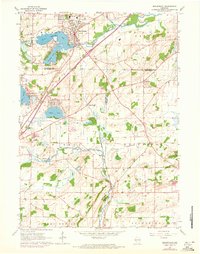
1960 Map of Mukwonago
USGS Topo · Published 1972About this map
Mukwonago serves as the primary hub of this landscape, situated where the Fox River and Honey Creek meander through a glacial terrain defined by numerous kettle lakes. By the mid-20th century, the area had established itself as a significant recreational and residential corridor, evidenced by the clusters of cottages around Lake Beulah, Potter Lake, and Lower Phantom Lake. Purple map revisions from 1971 show the expansion of the road network and residential footprints as the region transitioned from a purely agricultural base toward a more suburban character.
Find a feature on this map
34 named features on this map. Tap any name to fly to it.
Don’t see what you’re looking for? This feature index may not catch every label — zoom into the map to look around manually.
Map Details
Editions of this 1960 Mukwonago Map
4 editions found
Other maps of this area

1891 · Muskego
USGS Topo · 1:62,500

1892 · Eagle
USGS Topo · 1:62,500

1893 · Silver Lake
USGS Topo · 1:62,500

1893 · Geneva
USGS Topo · 1:62,500

1894 · Eagle
USGS Topo · 1:62,500

1897 · Eagle
USGS Topo · 1:62,500

1901 · Muskego
USGS Topo · 1:62,500

1904 · Lake Geneva
USGS Topo · 1:62,500

1906 · Eagle
USGS Topo · 1:62,500

1906 · Silver Lake
USGS Topo · 1:62,500