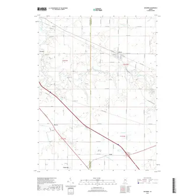
2019 Map of Mulberry
USGS Topo · Published 2019About this map
Mulberry stands at the center of this rural Indiana landscape, where the grain-growing plains of Clinton and Tippecanoe counties are carved by the winding course of South Fork Wildcat Creek. The terrain is punctuated by small agricultural settlements and a network of county roads that follow the rigid lines of the Public Land Survey System. Genealogical researchers will find several well-preserved family burial grounds, including Baker Cem, Newcomer Cem, and Holladay Cem, which are scattered throughout the townships. Notable elevation changes occur near the creek, specifically at Kirkridge Bluff in the northwest. The map captures a high degree of hydrographic detail, tracing the paths of Lauramie Cr and McClellan-Fickle Ditch, reflecting the managed drainage essential to the area's farming heritage. Smaller rail-aligned or road-junction hamlets like Wyandot, Fickle, and Clarks Hill further illustrate the early 21st-century settlement patterns of the region.
Find a feature on this map
66 named features on this map. Tap any name to fly to it.
Don’t see what you’re looking for? This feature index may not catch every label — zoom into the map to look around manually.
Map Details
Editions of this 2019 Mulberry Map
This is the sole edition of this map. No revisions or reprints were ever made.
Other maps of this area

1953 · Danville
USGS Topo · 1:250,000

1955 · Danville
USGS Topo · 1:250,000

1956 · Danville
USGS Topo · 1:250,000

1958 · Kirkpatrick
USGS Topo · 1:24,000

1961 · Mulberry
USGS Topo · 1:24,000

1961 · Pyrmont
USGS Topo · 1:24,000

1961 · Stockwell
USGS Topo · 1:24,000

1961 · Lafayette East
USGS Topo · 1:24,000

1961 · Rossville
USGS Topo · 1:24,000

1961 · Frankfort
USGS Topo · 1:24,000