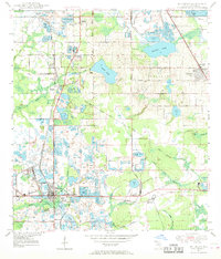
1949 Map of Mulberry
USGS Topo · Published 1969About this map
Phosphate mining defines the landscape of this 1949 survey, where extensive Strip Mines and tailings ponds surround the industrial hub of Mulberry. The town serves as a critical junction for the Atlantic Coast Line and Seaboard Air Line railroads, which weave through a geography reshaped by extraction. To the north, older community centers like Medulla and Ardella persist, anchored by local institutions such as St Johns Ch Medulla and Medulla Sch. The contrast between the natural hydrology of Scott Lake or Banana Lake and the engineered mine pits illustrates a territory in mid-century transition. Genealogists can locate several historic burial grounds, including Prairie Cem and Malloy Cem, while local historians can trace the growth of outlying settlements like Fountain Heights and Highland City during Polk County's post-war industrial era.
Find a feature on this map
41 named features on this map. Tap any name to fly to it.
Don’t see what you’re looking for? This feature index may not catch every label — zoom into the map to look around manually.
Map Details
Editions of this 1949 Mulberry Map
5 editions found
Other maps of this area

1944 · Plant City
USGS Topo · 1:31,680

1944 · Lakeland
USGS Topo · 1:31,680

1944 · Auburndale
USGS Topo · 1:31,680

1949 · Mulberry
USGS Topo · 1:24,000

1949 · Bartow
USGS Topo · 1:24,000

1949 · Bradley Junction
USGS Topo · 1:24,000

1950 · Mulberry
USGS Topo · 1:24,000

1950 · Bartow
USGS Topo · 1:24,000

1950 · Bradley Junction
USGS Topo · 1:24,000

1952 · Homeland
USGS Topo · 1:24,000