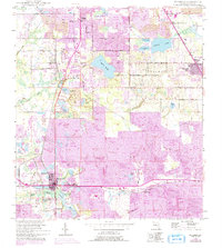
1949 Map of Mulberry
USGS Topo · Published 1993About this map
Extensive industrial strip mining defines the landscape south of Lakeland during this mid-century period, where massive Strip Mine operations and subsequent Reclaimed Strip Mine tracts surround the phosphate-producing center of Mulberry. The area maintains its rural-industrial character with several established settlements and crossroads including Highland City, Medulla, and Kingsford. Transport and trade are facilitated by the Seaboard Coast Line railroad, which links these extraction sites to regional markets. Amidst the industrial activity, significant natural water bodies such as Banana Lake and Scott Lake provide geographic contrast. Local history and genealogy are anchored by landmarks like Fitzgerald Cem, Medulla Cem, and churches including St Johns Ch and Mt Olive Ch. The mapping reveals the expansion of residential life alongside heavy industry, visible in newer developments like Fountain Heights and the varied trailer parks and drives that connect the growing Polk County communities.
Find a feature on this map
46 named features on this map. Tap any name to fly to it.
Don’t see what you’re looking for? This feature index may not catch every label — zoom into the map to look around manually.
Map Details
Editions of this 1949 Mulberry Map
5 editions found
Other maps of this area

1944 · Plant City
USGS Topo · 1:31,680

1944 · Lakeland
USGS Topo · 1:31,680

1944 · Auburndale
USGS Topo · 1:31,680

1949 · Mulberry
USGS Topo · 1:24,000

1949 · Bartow
USGS Topo · 1:24,000

1949 · Bradley Junction
USGS Topo · 1:24,000

1950 · Mulberry
USGS Topo · 1:24,000

1950 · Bartow
USGS Topo · 1:24,000

1950 · Bradley Junction
USGS Topo · 1:24,000

1952 · Homeland
USGS Topo · 1:24,000