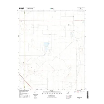
2016 Map of Muleshoe NE
USGS Topo · Published 2016About this map
Blackwater Draw defines the central topography of this Lamb County landscape, marking an ancient drainage path across the High Plains. In this 2016 survey, the land is largely organized by an exacting grid of county roads, including Co Rd 74 and Co Rd 35, reflecting a deeply entrenched agricultural and ranching infrastructure. These straight-line boundaries are occasionally interrupted by natural depressions and seasonal basins, such as Spring Lake and Soda Lake, which offer vital water sources and distinctive geological markers in an otherwise uniform terrain. The western edge of the map follows the straight-line border between Bailey Co and Lamb Co, a survey line that cuts across the natural flow of the draw. This intersection of natural geography and geometric human organization highlights how the modern Texas Panhandle has been partitioned and utilized for commercial and agricultural production.
Find a feature on this map
17 named features on this map. Tap any name to fly to it.
Don’t see what you’re looking for? This feature index may not catch every label — zoom into the map to look around manually.
Map Details
Editions of this 2016 Muleshoe NE Map
This is the sole edition of this map. No revisions or reprints were ever made.
Other maps of this area

1954 · Clovis
USGS Topo · 1:250,000

1958 · Clovis
USGS Topo · 1:250,000

1962 · Muleshoe
USGS Topo · 1:24,000

1962 · Needmore
USGS Topo · 1:24,000

1962 · Amherst
USGS Topo · 1:24,000

1962 · Sudan
USGS Topo · 1:24,000

1962 · Muleshoe NE
USGS Topo · 1:24,000

1963 · Earth
USGS Topo · 1:24,000

1963 · Dodd
USGS Topo · 1:24,000

1963 · Lazbuddie SW
USGS Topo · 1:24,000