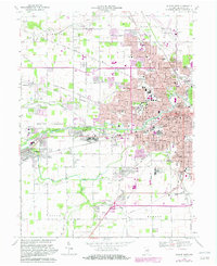
1969 Map of Muncie West
USGS Topo · Published 1982About this map
Ball State University and the expansion of western Muncie define this mid-century landscape. The White River flows through the heart of the region, connecting the urban core with the growing settlement of Yorktown to the west. Industrial and civic infrastructure is prominently mapped, including the Filtration Plant and Sewage Disposal facilities near the river, alongside local landmarks like Ball Memorial Hospital and the County Fairgrounds.
Find a feature on this map
81 named features on this map. Tap any name to fly to it.
Don’t see what you’re looking for? This feature index may not catch every label — zoom into the map to look around manually.
Map Details
Editions of this 1969 Muncie West Map
3 editions found
Other maps of this area

1952 · Muncie East
USGS Topo · 1:24,000

1952 · Muncie West
USGS Topo · 1:24,000

1953 · Muncie
USGS Topo · 1:250,000

1956 · Muncie
USGS Topo · 1:250,000

1960 · Gilman
USGS Topo · 1:24,000

1960 · Middletown
USGS Topo · 1:24,000

1960 · Eaton
USGS Topo · 1:24,000

1960 · Mount Pleasant
USGS Topo · 1:24,000

1960 · Wheeling
USGS Topo · 1:24,000

1960 · Sulphur Springs
USGS Topo · 1:24,000