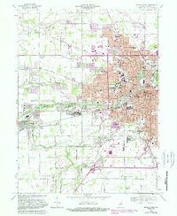
1969 Map of Muncie West
USGS Topo · Published 1988About this map
The White River anchors this landscape as it flows westward through Muncie, marking a transition from the dense urban grid of the city to the burgeoning suburbs of the late 1960s. Ball State University stands as a primary institutional landmark, surrounded by a high concentration of neighborhood schools like Storer Jr High Sch and Mitchell Sch. To the west, the community of Yorktown is clearly defined, situated near the confluence of Buck Creek and the river, while smaller settlements such as Cammack and West Muncie remain distinct.
Find a feature on this map
65 named features on this map. Tap any name to fly to it.
Don’t see what you’re looking for? This feature index may not catch every label — zoom into the map to look around manually.
Map Details
Editions of this 1969 Muncie West Map
3 editions found
Other maps of this area

1952 · Muncie East
USGS Topo · 1:24,000

1952 · Muncie West
USGS Topo · 1:24,000

1953 · Muncie
USGS Topo · 1:250,000

1956 · Muncie
USGS Topo · 1:250,000

1960 · Gilman
USGS Topo · 1:24,000

1960 · Middletown
USGS Topo · 1:24,000

1960 · Eaton
USGS Topo · 1:24,000

1960 · Mount Pleasant
USGS Topo · 1:24,000

1960 · Wheeling
USGS Topo · 1:24,000

1960 · Sulphur Springs
USGS Topo · 1:24,000