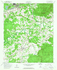
1956 Map of Munford
USGS Topo · Published 1966About this map
The Anniston Ordnance Depot anchors the northern landscape of this mid-1950s survey, illustrating the significant military footprint in the region during the post-war era. This industrial presence contrasts with the rural character of settlements like Munford and Jenifer, which developed along the rail corridors of the Southern and Louisville and Nashville railroads. The map records a dense network of local social institutions, including the Sweet Home Sch, Halls Grove Ch, and Bethlehem Ch, which served the farming communities clustered near Choccolocco Creek. To the east, the rising slopes of Coldwater Mountain and Kentuck Mtn mark the edge of the Talladega National Forest, while specialized sites like the State Fish Hatchery and several pipeline corridors indicate the evolving management of Alabama's natural and energy resources at mid-century.
Find a feature on this map
40 named features on this map. Tap any name to fly to it.
Don’t see what you’re looking for? This feature index may not catch every label — zoom into the map to look around manually.
Map Details
Editions of this 1956 Munford Map
4 editions found

Other maps of this area

1889 · Springville
USGS Topo · 1:125,000

1890 · Talladega
USGS Topo · 1:125,000

1891 · Ashland
USGS Topo · 1:125,000

1892 · Springville
USGS Topo · 1:125,000

1892 · Talladega
USGS Topo · 1:125,000

1900 · Anniston
USGS Topo · 1:125,000

1943 · Talladega
USGS Topo · 1:62,500

1946 · Talladega
USGS Topo · 1:62,500

1947 · Oxford
USGS Topo · 1:24,000

1947 · Anniston
USGS Topo · 1:24,000