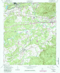
1956 Map of Munford
USGS Topo · Published 1985About this map
Munford and Jenifer anchor this mid-century look at the border between Calhoun and Talladega Counties, where the agricultural valley meets the rising slopes of Coldwater Mountain. The Southern railroad corridor is central to the landscape, connecting small rural hubs and industrial infrastructure like the Army Depot and the State Fish Hatchery. Significant local history is preserved through the placement of rural institutions such as Halls Grove Ch, Bethlehem Cem, and several schoolhouses like Hillside Sch and Sweet Home Sch.
Find a feature on this map
42 named features on this map. Tap any name to fly to it.
Don’t see what you’re looking for? This feature index may not catch every label — zoom into the map to look around manually.
Map Details
Editions of this 1956 Munford Map
4 editions found

Other maps of this area

1889 · Springville
USGS Topo · 1:125,000

1890 · Talladega
USGS Topo · 1:125,000

1891 · Ashland
USGS Topo · 1:125,000

1892 · Springville
USGS Topo · 1:125,000

1892 · Talladega
USGS Topo · 1:125,000

1900 · Anniston
USGS Topo · 1:125,000

1943 · Talladega
USGS Topo · 1:62,500

1946 · Talladega
USGS Topo · 1:62,500

1947 · Oxford
USGS Topo · 1:24,000

1947 · Anniston
USGS Topo · 1:24,000