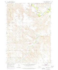
1951 Map of Murdo 3 NE
USGS Topo · Published 1977About this map
The White River carves a winding course through the northern portion of this South Dakota landscape, defining the jagged physical boundary between Mellette Co and Jones County. Much of the southern terrain is dominated by the broad Cottonwood Valley, where Cottonwood Creek meanders through a network of dry coulees and rising ridges. This 1951 field survey highlights the remote rural character of the Rosebud Indian Reservation at mid-century, where the local social infrastructure is represented by solitary landmarks like the Valley View Sch. The intricate contouring reveals the transition from the high prairie flats of Mullen down into the eroded breaks along the river, illustrating the topographical challenges faced by early ranchers and residents of this region.
Find a feature on this map
8 named features on this map. Tap any name to fly to it.
Don’t see what you’re looking for? This feature index may not catch every label — zoom into the map to look around manually.
Map Details
Editions of this 1951 Murdo 3 NE Map
3 editions found
Other maps of this area

1951 · Okaton SW
USGS Topo · 1:24,000

1951 · Westover
USGS Topo · 1:24,000

1951 · Murdo SW
USGS Topo · 1:24,000

1951 · Murdo 3 NW
USGS Topo · 1:24,000

1951 · Murdo 3 NE
USGS Topo · 1:24,000

1951 · Okaton SE
USGS Topo · 1:24,000

1955 · Martin
USGS Topo · 1:250,000

1958 · Martin
USGS Topo · 1:250,000
1982 · Murdo 3 NW
USGS Topo · 1:25,000

1982 · White River East
USGS Topo · 1:24,000