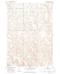
1951 Map of Murdo SW
USGS Topo · Published 1977About this map
Murdo Municipal Airport sits near the northern boundary of this Jones County landscape, marking a point of modern infrastructure in a region otherwise defined by the complex drainages of Horse Creek and Hay Creek. This 1951 field-checked survey reveals the sprawling township divisions of Murdo, Buffalo, Mullen, and Westover, highlighting the rural layout of south-central South Dakota mid-century. Educational hubs like the East Buffalo Sch provided local centers for the ranching families scattered across these plains.
Find a feature on this map
12 named features on this map. Tap any name to fly to it.
Don’t see what you’re looking for? This feature index may not catch every label — zoom into the map to look around manually.
Map Details
Editions of this 1951 Murdo SW Map
3 editions found
Other maps of this area

1951 · Murdo SE
USGS Topo · 1:24,000

1951 · White River NE
USGS Topo · 1:24,000

1951 · Westover
USGS Topo · 1:24,000

1951 · Murdo SW
USGS Topo · 1:24,000

1951 · Murdo 3 NE
USGS Topo · 1:24,000

1951 · Okaton SE
USGS Topo · 1:24,000

1955 · Martin
USGS Topo · 1:250,000

1958 · Martin
USGS Topo · 1:250,000

1972 · Draper
USGS Topo · 1:24,000

1972 · Murdo
USGS Topo · 1:24,000