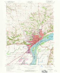
1953 Map of Muscatine
USGS Topo · Published 1971About this map
The Mississippi River dominates this mid-century survey, defining the industrial and civic layout of Muscatine and its surrounding Iowa and Illinois townships. The riverbank is heavily utilized, featuring the Lock and Dam No 16 and the Muscatine Municipal Electric Plant, alongside islands like Towhead Island and Hog Island. The town's social fabric is visible through its dense concentration of neighborhood landmarks, including Jefferson High School, St Marys Church and School, and the County Hospital.
Find a feature on this map
45 named features on this map. Tap any name to fly to it.
Don’t see what you’re looking for? This feature index may not catch every label — zoom into the map to look around manually.
Map Details
Editions of this 1953 Muscatine Map
Other maps of this area

1890 · Durant
USGS Topo · 1:62,500

1891 · Wilton Junction
USGS Topo · 1:62,500

1894 · Durant
USGS Topo · 1:62,500

1901 · Rock Island
USGS Topo · 1:125,000

1901 · Stanwood
USGS Topo · 1:125,000

1910 · Rock Island
USGS Topo · 1:125,000

1916 · Edgington
USGS Topo · 1:62,500

1938 · Edgington
USGS Topo · 1:62,500

1948 · Muscatine
USGS Topo · 1:62,500

1953 · Wilton Junction
USGS Topo · 1:24,000