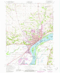
1953 Map of Muscatine
USGS Topo · Published 1981About this map
The Mississippi River dominates the eastern half of this survey, where the industrial and civic heart of Muscatine sits along the riverfront. The town's growth is evident in the transition from established neighborhoods near Weed Park to the emerging commercial zones marked by a Shopping Center and a Trailer Park. Significant infrastructure, including the Lock and Dam No 16 and the Muscatine Municipal Electric Plant, anchors the shoreline, while the Chicago Rock Island and Pacific railroad traces the river’s curve through the city.
Find a feature on this map
58 named features on this map. Tap any name to fly to it.
Don’t see what you’re looking for? This feature index may not catch every label — zoom into the map to look around manually.
Map Details
Editions of this 1953 Muscatine Map
Other maps of this area

1890 · Durant
USGS Topo · 1:62,500

1891 · Wilton Junction
USGS Topo · 1:62,500

1894 · Durant
USGS Topo · 1:62,500

1901 · Rock Island
USGS Topo · 1:125,000

1901 · Stanwood
USGS Topo · 1:125,000

1910 · Rock Island
USGS Topo · 1:125,000

1916 · Edgington
USGS Topo · 1:62,500

1938 · Edgington
USGS Topo · 1:62,500

1948 · Muscatine
USGS Topo · 1:62,500

1953 · Wilton Junction
USGS Topo · 1:24,000