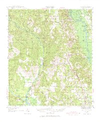
1941 Map of Muscogee
USGS Topo · Published 1968About this map
The Perdido River and Escambia River define this borderlands landscape, where Florida meets Alabama in a complex network of waterways and timber-era settlements. In the early 1940s, the region was anchored by rural community hubs like Muscogee, Cantonment, and Molino, each connected by the industrial arteries of the Louisville and Nashville RR and the San Francisco RR. The map reveals a dense social fabric of the period, documenting numerous rural schools and places of worship such as Tate Sch, Pughs Chapel, and Latham Chapel. Along the riverbanks, distinct landings and islands like Cottage Hill Landing and Parker Island indicate a landscape heavily shaped by river-based transport and the local fishing economy. The presence of numerous named lakes, including Blackfish Lake and Sawdust Lake, suggests a low-lying terrain characterized by backwaters and cypress swamps that dominated the space between the rising timberlands.
Find a feature on this map
82 named features on this map. Tap any name to fly to it.
Don’t see what you’re looking for? This feature index may not catch every label — zoom into the map to look around manually.
Map Details
Editions of this 1941 Muscogee Map
2 editions found
Other maps of this area

1920 · Milton
USGS Topo · 1:62,500

1920 · Robertsdale
USGS Topo · 1:62,500

1921 · Bon Secour
USGS Topo · 1:62,500

1921 · Pensacola
USGS Topo · 1:62,500

1921 · Fort Barrancas
USGS Topo · 1:62,500

1921 · Muscogee
USGS Topo · 1:62,500

1941 · Fort Barrancas
USGS Topo · 1:62,500

1941 · Muscogee
USGS Topo · 1:62,500

1941 · Robertsdale
USGS Topo · 1:62,500

1941 · Pensacola
USGS Topo · 1:62,500