
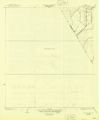
1932 Map of Mustang Bayou
USGS Topo · Published 1932About this map
Arcadia stands as the primary point of settlement on this preliminary 1932 sheet, which documents the coastal prairie landscape along the border of Galveston Co and Brazoria Co. Much of the map reflects an unsurveyed area, captured here during a transition in regional mapping by the Texas Reclamation Department and the U.S. Geological Survey. The sparse development shown in the northeast corner reveals a grid of early roads and field boundaries typical of the period's agricultural expansion before more intensive coastal development. The involvement of the Galveston County Commissioners Court, including County Judge E. B. Holman and County Engineer C. C. Washington, underscores the local administrative effort to document this territory for drainage and land reclamation purposes during the late 1920s and early 1930s.
Find a feature on this map
3 named features on this map. Tap any name to fly to it.
Don’t see what you’re looking for? This feature index may not catch every label — zoom into the map to look around manually.
Map Details
Editions of this 1932 Mustang Bayou Map
2 editions found
Other maps of this area

1929 · Dickinson
USGS Topo · 1:24,000

1929 · Karankawa Lake
USGS Topo · 1:24,000

1929 · Algoa
USGS Topo · 1:24,000

1929 · Hitchcock
USGS Topo · 1:24,000

1932 · Algoa
USGS Topo · 1:31,680

1932 · Dickinson
USGS Topo · 1:31,680

1932 · Hitchcock
USGS Topo · 1:31,680

1933 · Karankawa Lake
USGS Topo · 1:31,680

1943 · Danbury
USGS Topo · 1:31,680

1943 · Mustang Bayou
USGS Topo · 1:31,680