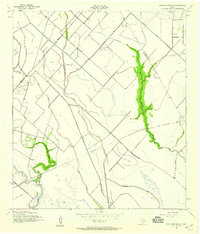
1943 Map of Mustang Bayou
USGS Topo · Published 1959About this map
Mustang Bayou and its winding tributaries dominate this coastal Texas landscape during the early 1940s, illustrating the complex hydrology of the Gulf Coast prairie. The area is defined by the transition from natural waterways like Halls Bayou and Chocolate Bayou to man-made irrigation and drainage infrastructure such as the Briscoe Canal. This survey captures the region's agricultural and industrial utility, where scattered Oil Wells and a Pumping Sta appear alongside rural landmarks. For genealogists, the German Cem near the northern boundary provides a specific point of historical interest. The Missouri Pacific railroad cuts diagonally across the northwest, serving as a primary transit artery through the marshy terrain that straddles the Brazoria and Galveston county line.
Find a feature on this map
13 named features on this map. Tap any name to fly to it.
Don’t see what you’re looking for? This feature index may not catch every label — zoom into the map to look around manually.
Map Details
Editions of this 1943 Mustang Bayou Map
2 editions found

Other maps of this area

1929 · Dickinson
USGS Topo · 1:24,000

1929 · Karankawa Lake
USGS Topo · 1:24,000

1929 · Algoa
USGS Topo · 1:24,000

1929 · Hitchcock
USGS Topo · 1:24,000

1932 · Algoa
USGS Topo · 1:31,680

1932 · Dickinson
USGS Topo · 1:31,680

1932 · Hitchcock
USGS Topo · 1:31,680

1932 · Mustang Bayou
USGS Topo · 1:31,680

1933 · Karankawa Lake
USGS Topo · 1:31,680

1943 · Danbury
USGS Topo · 1:31,680