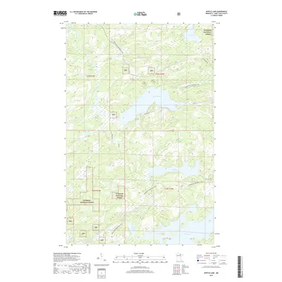
2019 Map of Myrtle Lake
USGS Topo · Published 2019About this map
Superior National Forest defines the character of this northern landscape, where a dense network of waterways and wetlands persists in Saint Louis County. The terrain is defined by a series of major lakes, including the central Myrtle Lake, the southern Elbow Lake and Little Elbow Lake, and Ban Lake to the east. These water bodies are connected by the winding courses of the Pelican River and Elbow River, creating a complex aquatic system that has historically shaped travel and recreation in the region. Transportation is primarily facilitated by specialized routes like the Arrowhead Snowmobile Trail, which traverses the forest alongside local thoroughfares such as Orr Buyck Rd and Wolf Knoll Rd. This modern survey documents the continued preservation of the forest's interior, showing limited development centered around small access roads like Autio Rd and S Ban Lake Spr.
Find a feature on this map
22 named features on this map. Tap any name to fly to it.
Don’t see what you’re looking for? This feature index may not catch every label — zoom into the map to look around manually.
Map Details
Editions of this 2019 Myrtle Lake Map
This is the sole edition of this map. No revisions or reprints were ever made.
Other maps of this area

1954 · Hibbing
USGS Topo · 1:250,000

1954 · International Falls
USGS Topo · 1:250,000

1957 · Hibbing
USGS Topo · 1:250,000

1957 · International Falls
USGS Topo · 1:250,000

1958 · International Falls
USGS Topo · 1:250,000

1958 · Hibbing
USGS Topo · 1:250,000

1964 · Hibbing
USGS Topo · 1:250,000

1964 · Haley
USGS Topo · 1:24,000

1964 · Gheen
USGS Topo · 1:24,000
1964 · Norwegian Bay
USGS Topo · 1:24,000