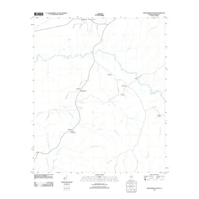
2011 Map of Myrtlewood South
USGS Topo · Published 2011About this map
Myrtlewood serves as the northern anchor for this Marengo County landscape, characterized by its intricate network of drainage systems feeding into the Beaver Creek basin. The area's social history is preserved in its numerous rural burying grounds, including the Geneva Presbyterian Church Cemetery and James Chapel Cemetery, which mark the small crossroads communities of Geneva and Half Acre. The terrain is defined by winding waterways such as Little Beaver Creek, Mill Creek, and Landrums Creek, which dictate the placement of local roads like Campground Rd and Rembert Hill Rd. A notable crossing exists at the Iron Bridge over Beaver Creek, a structural landmark in a region primarily shaped by agricultural and timber interests. The distribution of family-centered landmarks like Howell Cemetery and Campground Cemetery suggests a deeply rooted local genealogy tied to these specific rural clusters.
Find a feature on this map
40 named features on this map. Tap any name to fly to it.
Don’t see what you’re looking for? This feature index may not catch every label — zoom into the map to look around manually.
Map Details
Editions of this 2011 Myrtlewood South Map
This is the sole edition of this map. No revisions or reprints were ever made.
Other maps of this area

1953 · Montgomery
USGS Topo · 1:250,000

1953 · Meridian
USGS Topo · 1:250,000

1956 · Montgomery
USGS Topo · 1:250,000

1957 · Meridian
USGS Topo · 1:250,000

1957 · Montgomery
USGS Topo · 1:250,000

1965 · Meridian
USGS Topo · 1:250,000

1970 · Myrtlewood North
USGS Topo · 1:24,000

1970 · Linden
USGS Topo · 1:24,000

1971 · Whitfield
USGS Topo · 1:24,000
1978 · Pennington
USGS Topo · 1:24,000