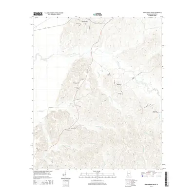
2014 Map of Myrtlewood South
USGS Topo · Published 2014About this map
Myrtlewood sits at the northern edge of this Marengo County landscape, where the local road network of Al-114 and Al-69 connects small communities across a terrain defined by many winding waterways. The settlement pattern is largely rural, characterized by small clusters like Campground, Half Acre, and Geneva. The area is notably dense with burial sites and centers of worship, such as the Geneva Presbyterian Church Cem, James Chapel Cem, and the Beaver Creek Baptist Cem. These locations, alongside the Community Cem and Howell Cem, provide significant landmarks for those tracing local family histories. The landscape is carved by a complex drainage system including Beaver Creek, Mill Cr, and Landrums Cr, which flow through the elevations of the Reabert Hills. An Iron Bridge crossing Beaver Creek further highlights the historical infrastructure connecting these timbered and agricultural spaces.
Find a feature on this map
46 named features on this map. Tap any name to fly to it.
Don’t see what you’re looking for? This feature index may not catch every label — zoom into the map to look around manually.
Map Details
Editions of this 2014 Myrtlewood South Map
This is the sole edition of this map. No revisions or reprints were ever made.
Other maps of this area

1953 · Montgomery
USGS Topo · 1:250,000

1953 · Meridian
USGS Topo · 1:250,000

1956 · Montgomery
USGS Topo · 1:250,000

1957 · Meridian
USGS Topo · 1:250,000

1957 · Montgomery
USGS Topo · 1:250,000

1965 · Meridian
USGS Topo · 1:250,000

1970 · Myrtlewood North
USGS Topo · 1:24,000

1970 · Linden
USGS Topo · 1:24,000

1971 · Whitfield
USGS Topo · 1:24,000
1978 · Pennington
USGS Topo · 1:24,000