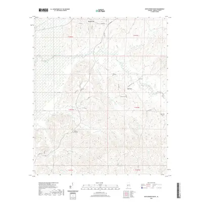
2020 Map of Myrtlewood South
USGS Topo · Published 2020About this map
The town of Myrtlewood sits along the northern edge of this landscape, where residential streets like Magnolia St and Cedar Ave meet the path of AL Highway 69. To the south, the settlement of Half Acre is positioned near the Iron Bridge crossing over Beaver Creek. This portion of Marengo County is defined by a dense network of watercourses, including Landrums Cr and Double Cr, which cut through the terrain. For those researching local family histories, several community landmarks appear, such as the Geneva Presbyterian Church Cem and the Beaver Creek Baptist Cem. The map reveals how local infrastructure, like CO Hwy 17 and CO Hwy 11, follows the natural contours of the creeks and ridges, connecting the small agrarian communities and religious centers that have long shaped this Alabama interior.
Find a feature on this map
48 named features on this map. Tap any name to fly to it.
Don’t see what you’re looking for? This feature index may not catch every label — zoom into the map to look around manually.
Map Details
Editions of this 2020 Myrtlewood South Map
This is the sole edition of this map. No revisions or reprints were ever made.
Other maps of this area

1953 · Montgomery
USGS Topo · 1:250,000

1953 · Meridian
USGS Topo · 1:250,000

1956 · Montgomery
USGS Topo · 1:250,000

1957 · Meridian
USGS Topo · 1:250,000

1957 · Montgomery
USGS Topo · 1:250,000

1965 · Meridian
USGS Topo · 1:250,000

1970 · Myrtlewood North
USGS Topo · 1:24,000

1970 · Linden
USGS Topo · 1:24,000

1971 · Whitfield
USGS Topo · 1:24,000
1978 · Pennington
USGS Topo · 1:24,000