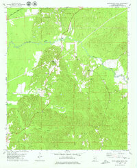
1978 Map of Myrtlewood South
USGS Topo · Published 1979About this map
Myrtlewood sits at the northern edge of this Marengo County landscape, where the Meridian and Bigbee railroad cuts across the timber and creek lands of west Alabama. The area is defined by an intricate drainage system including Beaver Creek and its many tributaries, such as Little Beaver Creek, Mill Creek, and the various branches of Double Creek. This 1970s survey captures a rural environment where industrial infrastructure like a Pumping Station, Compressor Station, and Gravel Pits exists alongside long-established community anchors. Genealogy researchers will find several localized landmarks, including James Chapel, Geneva Ch, and the Community Cem, which alongside the small settlement of Half Acre, illustrate the dispersed social fabric of the county during this era.
Find a feature on this map
24 named features on this map. Tap any name to fly to it.
Don’t see what you’re looking for? This feature index may not catch every label — zoom into the map to look around manually.
Map Details
Editions of this 1978 Myrtlewood South Map
This is the sole edition of this map. No revisions or reprints were ever made.
Other maps of this area

1953 · Montgomery
USGS Topo · 1:250,000

1953 · Meridian
USGS Topo · 1:250,000

1956 · Montgomery
USGS Topo · 1:250,000

1957 · Meridian
USGS Topo · 1:250,000

1957 · Montgomery
USGS Topo · 1:250,000

1965 · Meridian
USGS Topo · 1:250,000

1970 · Myrtlewood North
USGS Topo · 1:24,000

1970 · Linden
USGS Topo · 1:24,000

1971 · Whitfield
USGS Topo · 1:24,000
1978 · Pennington
USGS Topo · 1:24,000