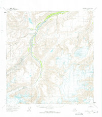
1959 Map of Nabesna A-5
USGS Topo · Published 1975About this map
Nabesna Glacier and Jacksina Glacier dominate this 1950s interior landscape, where ice and high-altitude drainage systems shape the terrain. The glacial runoff feeds into the winding Jacksina Creek, which serves as a primary corridor through the valley. To the north, Grizzly Lake and several smaller alpine bodies are tucked into the high ridges, while Mt Gordon stands as a prominent high point in the eastern portion of the survey. A single Pack Trail is the only indicated route of human passage through the northwest, highlighting the extreme isolation of the region before significant modern development. The map provides a look at the hydrography of the Wrangell Mountains area, featuring named tributaries like Monte Cristo Creek and Mesa Creek as they flow from the high ice fields toward the lower valleys.
Find a feature on this map
9 named features on this map. Tap any name to fly to it.
Don’t see what you’re looking for? This feature index may not catch every label — zoom into the map to look around manually.
Map Details
Editions of this 1959 Nabesna A-5 Map
3 editions found
Other maps of this area

1950 · Nabesna
USGS Topo · 1:250,000

1951 · McCarthy
USGS Topo · 1:250,000

1951 · Nabesna
USGS Topo · 1:250,000

1959 · Nabesna A-6
USGS Topo · 1:63,360

1959 · Nabesna A-4
USGS Topo · 1:63,360

1959 · McCarthy D-7
USGS Topo · 1:63,360

1959 · Nabesna A-5
USGS Topo · 1:63,360

1960 · Nabesna B-4
USGS Topo · 1:63,360

1960 · Nabesna B-5
USGS Topo · 1:63,360

1960 · McCarthy D-6
USGS Topo · 1:63,360