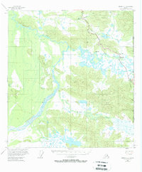
1955 Map of Nabesna C-1
USGS Topo · Published 1963About this map
The Alaska Yukon border defines the eastern edge of this mid-century survey, where the Alaska Highway serves as the primary artery for travel and trade. Small outposts such as the Border City Trading Post and Seaton Roadhouse mark the human presence along this remote corridor. Infrastructure of the era is clearly visible, including a Telephone Line and an Aboveground Pipeline that parallel the highway through the marshy lowlands of Scottie Creek.
Find a feature on this map
20 named features on this map. Tap any name to fly to it.
Don’t see what you’re looking for? This feature index may not catch every label — zoom into the map to look around manually.
Map Details
Editions of this 1955 Nabesna C-1 Map
3 editions found
Other maps of this area

1950 · Nabesna
USGS Topo · 1:250,000

1951 · Nabesna
USGS Topo · 1:250,000

1952 · Nabesna D-1
USGS Topo · 1:63,360

1954 · Nabesna D-2
USGS Topo · 1:63,360

1955 · Nabesna C-1
USGS Topo · 1:63,360

1955 · Nabesna C-2
USGS Topo · 1:63,360

1955 · Nabesna D-2
USGS Topo · 1:63,360

1960 · Nabesna B-2
USGS Topo · 1:63,360

1960 · Nabesna
USGS Topo · 1:250,000

1960 · Nabesna B-1
USGS Topo · 1:63,360