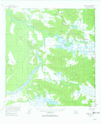
1955 Map of Nabesna C-1
USGS Topo · Published 1963About this map
The Alaska Highway cuts across the northeastern portion of this territory, serving as a vital link between the United States Canada border and the interior. Along this corridor, essential traveler outposts like the Seaton Roadhouse and the Border City Trading Post appear alongside the Scotty Creek Lodge, marking the mid-century infrastructure of the far north. To the west, the landscape is defined by the expansive braided channels of the Chisana River as it flows past the Black Hills. This survey highlights the era of post-war development in the subarctic, showing the coordination of the Telephone Line and Aboveground Pipeline following the highway route. The map documents a transition from traditional land use, represented by the High Cache, to the mechanized transport and communication networks essential for modern Alaskan settlement.
Find a feature on this map
21 named features on this map. Tap any name to fly to it.
Don’t see what you’re looking for? This feature index may not catch every label — zoom into the map to look around manually.
Map Details
Editions of this 1955 Nabesna C-1 Map
3 editions found
Other maps of this area

1950 · Nabesna
USGS Topo · 1:250,000

1951 · Nabesna
USGS Topo · 1:250,000

1952 · Nabesna D-1
USGS Topo · 1:63,360

1954 · Nabesna D-2
USGS Topo · 1:63,360

1955 · Nabesna C-1
USGS Topo · 1:63,360

1955 · Nabesna C-2
USGS Topo · 1:63,360

1955 · Nabesna D-2
USGS Topo · 1:63,360

1960 · Nabesna B-2
USGS Topo · 1:63,360

1960 · Nabesna
USGS Topo · 1:250,000

1960 · Nabesna B-1
USGS Topo · 1:63,360