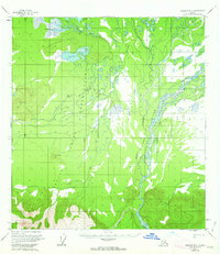
1955 Map of Nabesna D-3
USGS Topo · Published 1963About this map
The Tetlin Indian Reservation encompasses a vast stretch of the interior Alaska landscape on this mid-century survey, defined by a complex network of glacial rivers and isolated high ground. The Nabesna River and Kalutna River dominate the eastern drainage, while the braided Tetlin River winds through the southwestern portion of the quadrangle. This area is characterized by low-lying wetlands punctuated by prominent elevations such as Halthalda Hill and Kinshuda Hill.
Find a feature on this map
15 named features on this map. Tap any name to fly to it.
Don’t see what you’re looking for? This feature index may not catch every label — zoom into the map to look around manually.
Map Details
Editions of this 1955 Nabesna D-3 Map
2 editions found

Other maps of this area

1948 · Tanacross A-3
USGS Topo · 1:63,360

1948 · Tanacross A-4
USGS Topo · 1:63,360

1949 · Tanacross
USGS Topo · 1:250,000

1950 · Tanacross
USGS Topo · 1:250,000

1950 · Nabesna
USGS Topo · 1:250,000

1951 · Nabesna
USGS Topo · 1:250,000

1952 · Tanacross A-4
USGS Topo · 1:63,360

1952 · Tanacross A-3
USGS Topo · 1:63,360

1954 · Tanacross A-2
USGS Topo · 1:63,360

1954 · Nabesna D-2
USGS Topo · 1:63,360