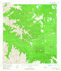
1960 Map of Nabesna D-4
USGS Topo · Published 1964About this map
The Tetlin Indian Reservation occupies the center of this landscape, where the meandering Tetlin River serves as a primary geographical artery through the interior. Surveyed in the mid-1950s and field-annotated in 1960, the map illustrates a transition between high alpine terrain and the lake-studded lowlands. Notable elevation changes are marked by Meiklejohn Pass in the northwest, while the presence of a Landing Strip near the river indicates the critical role of bush aviation in this roadless region. The network of waterways, including Moose Creek, Clearwater Creek, and Mice Creek, defines the drainage patterns of the Alaskan wilderness before more intensive modern development. This document also reflects the administrative landscape of the era, showing unsurveyed land lines predetermined by the Bureau of Land Management.
Find a feature on this map
12 named features on this map. Tap any name to fly to it.
Don’t see what you’re looking for? This feature index may not catch every label — zoom into the map to look around manually.
Map Details
Editions of this 1960 Nabesna D-4 Map
2 editions found
Other maps of this area

1948 · Tanacross A-3
USGS Topo · 1:63,360

1948 · Tanacross A-4
USGS Topo · 1:63,360

1948 · Nabesna D-5
USGS Topo · 1:63,360

1948 · Tanacross A-5
USGS Topo · 1:63,360

1949 · Tanacross
USGS Topo · 1:250,000

1949 · Tanacross A-5
USGS Topo · 1:63,360

1950 · Tanacross
USGS Topo · 1:250,000

1950 · Nabesna
USGS Topo · 1:250,000

1950 · Nabesna D-5
USGS Topo · 1:63,360

1951 · Nabesna
USGS Topo · 1:250,000