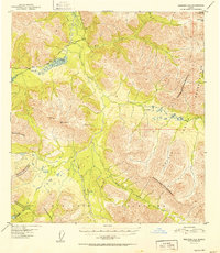
1952 Map of Nabesna D-5
USGS Topo · Published 1952About this map
The Mentasta Mountains dominate the interior landscape of this 1952 Alaskan survey, where the Little Tok River carves a valley through high-altitude terrain. This quadrangle captures a period of early infrastructure in the territory, centered on the Glenn Highway as it winds northwest past Mineral Lake. To the east, the Tetlin Indian Reservation occupies a significant portion of the map, its boundary clearly marked as it traverses across Tuck Creek and Buck Creek.
Find a feature on this map
19 named features on this map. Tap any name to fly to it.
Don’t see what you’re looking for? This feature index may not catch every label — zoom into the map to look around manually.
Map Details
Editions of this 1952 Nabesna D-5 Map
2 editions found

Other maps of this area

1948 · Tanacross A-6
USGS Topo · 1:63,360

1948 · Tanacross A-4
USGS Topo · 1:63,360

1948 · Nabesna C-6
USGS Topo · 1:63,360

1948 · Nabesna D-5
USGS Topo · 1:63,360

1948 · Tanacross A-5
USGS Topo · 1:63,360

1949 · Tanacross
USGS Topo · 1:250,000

1949 · Nabesna D-6
USGS Topo · 1:63,360

1949 · Tanacross A-5
USGS Topo · 1:63,360

1950 · Tanacross
USGS Topo · 1:250,000

1950 · Nabesna
USGS Topo · 1:250,000