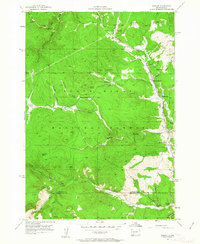
1956 Map of Nahant
USGS Topo · Published 1963About this map
The settlement of Nahant sits along the North Fork Rapid Creek as it appeared in the mid-1950s, serving as a focal point for ranching and transport in the heart of the Black Hills Forest. The Chicago Burlington and Quincy railroad line tracks along the creek beds, winding through a landscape defined by an extensive network of draws and springs. This survey documents a transition in rural education, noting the Nahant Sch alongside the Dumont Sch (Abandoned), suggesting a shift in local population centers. Numerous family operations are scattered across the terrain, including Juso Ranch, Bull Dog Ranch, and Sasse Ranch. Evidence of earlier infrastructure is visible in the Old Railroad Grade north of the current tracks. Significant for genealogists, the map also locates the Ward Cem near Ward Draw, providing a precise record of early homesteading footprints near the boundary of Lawrence and Pennington counties.
Find a feature on this map
44 named features on this map. Tap any name to fly to it.
Don’t see what you’re looking for? This feature index may not catch every label — zoom into the map to look around manually.
Map Details
Editions of this 1956 Nahant Map
4 editions found
Other maps of this area

1894 · Deadwood
USGS Topo · 1:125,000

1899 · Sturgis
USGS Topo · 1:62,500

1900 · Spearfish
USGS Topo · 1:62,500

1901 · Deadwood
USGS Topo · 1:125,000

1915 · Spearfish
USGS Topo · 1:62,500

1915 · Sturgis
USGS Topo · 1:62,500

1916 · Deadwood
USGS Topo · 1:125,000

1953 · Rapid City
USGS Topo · 1:250,000
1956 · Crooks Tower
USGS Topo · 1:24,000
1956 · Crows Nest Peak
USGS Topo · 1:24,000