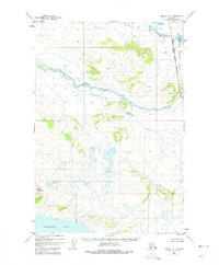
1951 Map of Naknek A-1
USGS Topo · Published 1975About this map
King Salmon River and its tributary, Gertrude Creek, dominate the central drainage of this wild Alaskan terrain as it was recorded in the early 1950s. The landscape transitions from the marshy lowlands surrounding the northern shore of Becharof Lake to the prominent heights of Blue Mountain. Toward the eastern edge, the Katmai National Monument Boundary marks the threshold of protected wilderness. A lone Cabin situated near the lake shore represents the only marked structure, highlighting the isolation of the region before modern infrastructure. This 1:63,360 scale survey provides a detailed look at the drainage patterns of Granite Creek and the complex system of small ponds and wetlands that characterize the southwestern Alaska peninsula during this era.
Find a feature on this map
8 named features on this map. Tap any name to fly to it.
Don’t see what you’re looking for? This feature index may not catch every label — zoom into the map to look around manually.
Map Details
Editions of this 1951 Naknek A-1 Map
3 editions found

Other maps of this area

1943 · Ugashik
USGS Topo · 1:250,000

1948 · Mt Katmai
USGS Topo · 1:250,000

1948 · Ugashik
USGS Topo · 1:250,000

1949 · Ugashik
USGS Topo · 1:250,000

1951 · Mt Katmai
USGS Topo · 1:250,000

1951 · Karluk
USGS Topo · 1:250,000

1951 · Mount Katmai A-6
USGS Topo · 1:63,360

1951 · Ugashik D-1
USGS Topo · 1:63,360

1951 · Mount Katmai B-6
USGS Topo · 1:63,360

1951 · Naknek B-1
USGS Topo · 1:63,360