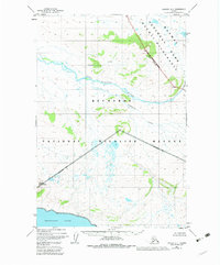
1951 Map of Naknek A-1
USGS Topo · Published 1983About this map
Becharof Lake defines the southern edge of this Alaskan landscape, where the vast wetlands of the Becharof National Wildlife Refuge meet the higher ground of the Katmai National Park and Wilderness. Surveyed in the early 1950s, the map documents a transition from the volcanic and mountainous terrain near Whale Mountain to the braided water systems of the King Salmon River. A lone Cabin situated near the lake shore represents one of the few signs of human infrastructure in this remote region. The map captures the natural drainage patterns of Granite Creek and Gertrude Creek, which flow through unpopulated territory before reaching the primary river systems. This edition reflects the 1980 establishment of federal reservation boundaries, overlaying administrative wilderness designations onto the mid-century topographic survey.
Find a feature on this map
10 named features on this map. Tap any name to fly to it.
Don’t see what you’re looking for? This feature index may not catch every label — zoom into the map to look around manually.
Map Details
Editions of this 1951 Naknek A-1 Map
3 editions found

Other maps of this area

1943 · Ugashik
USGS Topo · 1:250,000

1948 · Mt Katmai
USGS Topo · 1:250,000

1948 · Ugashik
USGS Topo · 1:250,000

1949 · Ugashik
USGS Topo · 1:250,000

1951 · Mt Katmai
USGS Topo · 1:250,000

1951 · Karluk
USGS Topo · 1:250,000

1951 · Mount Katmai A-6
USGS Topo · 1:63,360

1951 · Ugashik D-1
USGS Topo · 1:63,360

1951 · Mount Katmai B-6
USGS Topo · 1:63,360

1951 · Naknek B-1
USGS Topo · 1:63,360