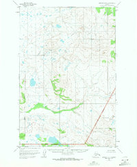
1951 Map of Naknek D-1
USGS Topo · Published 1971About this map
Katmai National Monument defines the eastern and southern portions of this landscape, established as a federal protected area decades before this 1951 aerial survey. The terrain is a complex network of glacial ponds and drainages, where the Bristol Bay Borough line meets the vast wilderness of the monument. Two primary watercourses, Pauls Creek and King Salmon Creek, dominate the drainage pattern as they flow westward through a mosaic of tundra and wetlands. This map, based on photogrammetric methods from 1951 with minor revisions in 1970, captures the area in an era of minimal human infrastructure, emphasizing the natural hydrography and the early administrative boundaries of the region. The absence of roads or established settlements highlights the remote character of the Alaska Peninsula during the mid-twentieth century.
Find a feature on this map
5 named features on this map. Tap any name to fly to it.
Don’t see what you’re looking for? This feature index may not catch every label — zoom into the map to look around manually.
Map Details
Editions of this 1951 Naknek D-1 Map
2 editions found
Other maps of this area

1948 · Mt Katmai
USGS Topo · 1:250,000

1951 · Dillingham
USGS Topo · 1:250,000

1951 · Mt Katmai
USGS Topo · 1:250,000

1951 · Mount Katmai C-6
USGS Topo · 1:63,360

1951 · Naknek D-1
USGS Topo · 1:63,360

1951 · Naknek C-1
USGS Topo · 1:63,360

1951 · Mount Katmai D-6
USGS Topo · 1:63,360

1951 · Iliamna A-8
USGS Topo · 1:63,360

1951 · Dillingham A-1
USGS Topo · 1:63,360

1952 · Iliamna
USGS Topo · 1:250,000