
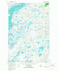
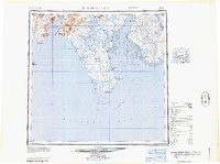
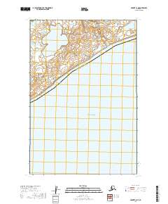
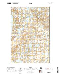
1952 Map of Naknek D-3
USGS Topo · Published 1971About this map
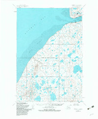
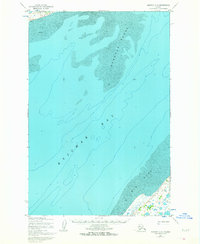
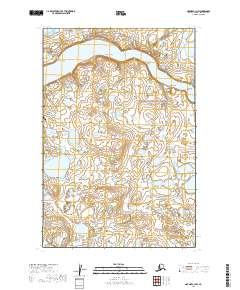
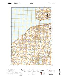
Kvichak River dominates this mid-century Alaskan landscape, shaping a complex network of tidal channels and inland water bodies within the Bristol Bay Borough. The terrain is characterized by broad alluvial features like Sea Gull Flat, extensive mudflats, and shifting sands, particularly near the prominent bend at Cape Horn. Aviation and maritime industry are central to the area's footprint, evidenced by the Kvichak Landing Strip and an adjacent Hangar, likely supporting the local Cannery operations and seasonal fishing activities typical of this region.
Find a feature on this map
20 named features on this map. Tap any name to fly to it.
Don’t see what you’re looking for? This feature index may not catch every label — zoom into the map to look around manually.
Map Details
Editions of this 1952 Naknek D-3 Map
2 editions found
Historical Maps of Kvichak Through Time
25 maps found

1945 Nushagak Bay
Bristol Bay Borough, AK

1949 Nushagak Bay
Bristol Bay Borough, AK
1951 Nushagak Bay
Bristol Bay Borough, AK
1952 Naknek C-2
Bristol Bay Borough, AK
1952 Naknek C-3
Bristol Bay Borough, AK
1952 Naknek C-4
Bristol Bay Borough, AK
1952 Naknek C-5
Bristol Bay Borough, AK
1952 Naknek D-2
Bristol Bay Borough, AK
1952 Naknek D-3
Bristol Bay Borough, AK
1952 Naknek D-4
Bristol Bay Borough, AK
1964 Nushagak Bay
Bristol Bay Borough, AK
2019 Naknek C-2 NE
Bristol Bay Borough, AK
2019 Naknek C-2 NW
Bristol Bay Borough, AK
2019 Naknek C-3 NE
Bristol Bay Borough, AK
2019 Naknek C-3 NW
Bristol Bay Borough, AK
2019 Naknek C-4 NE
Bristol Bay Borough, AK
2019 Naknek C-4 NW
Bristol Bay Borough, AK
2019 Naknek C-5 NW
Bristol Bay Borough, AK
2019 Naknek C-6 NE
Bristol Bay Borough, AK
2019 Naknek D-2 SE
Bristol Bay Borough, AK
2019 Naknek D-2 SW
Bristol Bay Borough, AK
2019 Naknek D-3 SE
Bristol Bay Borough, AK
2019 Naknek D-3 SW
Bristol Bay Borough, AK
2019 Naknek D-4 SE
Bristol Bay Borough, AK
2019 Naknek D-4 SW
Bristol Bay Borough, AK