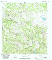
1986 Map of Nameless
USGS Topo · Published 1986About this map
Nameless sits at the heart of a landscape defined by deeply incised hollows and winding waterways along the Williamson and Travis County line. This mid-1980s revision reveals the rural character of the Texas Hill Country before significant suburban expansion, showing a network of ranching roads and remote family landmarks. The map documents numerous small burial grounds like Huddleston Cem and Miller Cem, alongside topographic features named for early families or local wildlife, such as Jess Maynard Hill and Polecat Knob. To the south, the influence of the Colorado River basin is evident as the terrain descends toward Lake Travis, where the community of Jonestown and the Lago Vista Bar-K Airpark mark the increasing accessibility of the region. The map tracks the drainages of Big Sandy Creek and North Fork Brushy Creek, illustrating the complex hydrology of this limestone-carved terrain.
Find a feature on this map
48 named features on this map. Tap any name to fly to it.
Don’t see what you’re looking for? This feature index may not catch every label — zoom into the map to look around manually.
Map Details
Editions of this 1986 Nameless Map
This is the sole edition of this map. No revisions or reprints were ever made.
Other maps of this area

1887 · Blanco
USGS Topo · 1:125,000

1887 · Burnet
USGS Topo · 1:125,000

1893 · Georgetown
USGS Topo · 1:125,000

1893 · Burnet
USGS Topo · 1:125,000

1894 · Blanco
USGS Topo · 1:125,000

1896 · Austin
USGS Topo · 1:125,000

1897 · Austin
USGS Topo · 1:125,000

1903 · Burnet
USGS Topo · 1:125,000

1909 · Burnet
USGS Topo · 1:125,000

1910 · Austin
USGS Topo · 1:125,000