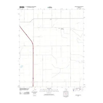
2010 Map of Nance Ranch
USGS Topo · Published 2010About this map
Saint Paul Cemetery sits near the northern edge of this Randall County landscape, marking a quiet point of reference in an area defined by agricultural research and expansive ranching operations. The terrain is notably influenced by the educational and agricultural heritage of the Nance Ranch - West Texas State University and the nearby Nanace Ranch. The geography is etched by several seasonal drainage ways, including Timber Creek, Sunday Creek, and North Cita Creek, which cut through the high plains toward the east. A structured grid of rural roads, such as Osage Rd and S Washington St, provides access to these working lands, while the label Abbott identifies a localized area within this section of the Texas Panhandle. This survey preserves the exact spatial relationship between university-affiliated lands and local family landmarks during the early 21st century.
Find a feature on this map
24 named features on this map. Tap any name to fly to it.
Don’t see what you’re looking for? This feature index may not catch every label — zoom into the map to look around manually.
Map Details
Editions of this 2010 Nance Ranch Map
This is the sole edition of this map. No revisions or reprints were ever made.
Other maps of this area

1954 · Amarillo
USGS Topo · 1:250,000

1954 · Plainview
USGS Topo · 1:250,000

1956 · Fortress Cliff
USGS Topo · 1:24,000

1956 · Thomas Ranch
USGS Topo · 1:24,000

1958 · Amarillo
USGS Topo · 1:250,000

1958 · Plainview
USGS Topo · 1:250,000

1960 · Canyon
USGS Topo · 1:62,500

1960 · The Palisades
USGS Topo · 1:24,000
1960 · Buffalo Stadium
USGS Topo · 1:24,000

1960 · Wayside
USGS Topo · 1:62,500