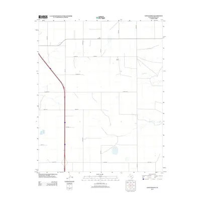
2012 Map of Nance Ranch
USGS Topo · Published 2012About this map
Nance Ranch and its surrounding High Plains landscape are defined by a regular grid of county roads and the southward corridor of I 27. This 2012 survey by the U.S. Geological Survey illustrates the intersection of modern transit and traditional ranching life in Randall County. Local genealogy and land use history center around the Saint Paul Cem, located near the intersection of S Osage St and the northern boundary road. The terrain is marked by the subtle drainage of ephemeral waterways, including Timber Cr, Sunday Cr, and N Cita Cr, which cut across the structured road network of Pondaseta Rd and Abbott Rd. The map also details essential local infrastructure like FM-1541 and several named thoroughfares such as Hungate Rd and Georgia St, which serve the agricultural parcels and remote homesites across this expanse of the Texas Panhandle.
Find a feature on this map
21 named features on this map. Tap any name to fly to it.
Don’t see what you’re looking for? This feature index may not catch every label — zoom into the map to look around manually.
Map Details
Editions of this 2012 Nance Ranch Map
This is the sole edition of this map. No revisions or reprints were ever made.
Other maps of this area

1954 · Amarillo
USGS Topo · 1:250,000

1954 · Plainview
USGS Topo · 1:250,000

1956 · Fortress Cliff
USGS Topo · 1:24,000

1956 · Thomas Ranch
USGS Topo · 1:24,000

1958 · Amarillo
USGS Topo · 1:250,000

1958 · Plainview
USGS Topo · 1:250,000

1960 · Canyon
USGS Topo · 1:62,500

1960 · The Palisades
USGS Topo · 1:24,000
1960 · Buffalo Stadium
USGS Topo · 1:24,000

1960 · Wayside
USGS Topo · 1:62,500