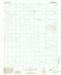
1984 Map of Nance Ranch
USGS Topo · Published 1984About this map
The Nance Ranch serves as a central hub in this section of the Texas Panhandle, illustrating the connection between academic research and the regional ranching economy. This landscape is defined by its drainage patterns, notably where Timber Creek and Sunday Creek cut through the high plains. A small Cem is located near the northern edge of the ranch property, providing a point of interest for local genealogical research. The presence of a Gravel Pit and various infrastructure like the Aqueduct and several pipelines across the terrain reflects the industrial demands of water management and resource extraction in Randall County during the early 1980s. The network of draws, such as Corral Draw and Bull Draw, further emphasizes the importance of natural topography to the area's historical land use.
Find a feature on this map
10 named features on this map. Tap any name to fly to it.
Don’t see what you’re looking for? This feature index may not catch every label — zoom into the map to look around manually.
Map Details
Editions of this 1984 Nance Ranch Map
This is the sole edition of this map. No revisions or reprints were ever made.
Other maps of this area

1954 · Amarillo
USGS Topo · 1:250,000

1954 · Plainview
USGS Topo · 1:250,000

1956 · Fortress Cliff
USGS Topo · 1:24,000

1956 · Thomas Ranch
USGS Topo · 1:24,000

1958 · Amarillo
USGS Topo · 1:250,000

1958 · Plainview
USGS Topo · 1:250,000

1960 · Canyon
USGS Topo · 1:62,500

1960 · The Palisades
USGS Topo · 1:24,000
1960 · Buffalo Stadium
USGS Topo · 1:24,000

1960 · Wayside
USGS Topo · 1:62,500