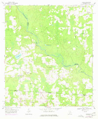
1956 Map of Nankin
USGS Topo · Published 1977About this map
The Withlacoochee River carves a winding path through this corner of the Deep South, marking the boundary between Brooks and Lowndes counties. This mid-century landscape is defined by its rural density, particularly the cluster of community churches that anchored local life, including Elam Ch, Ochlawilla Ch, and Columbia Ch. Near the settlement of Nankin, the terrain is dotted with small water bodies like Fearnside Lake and Montgomery Pond, set against a backdrop of wetlands and low-lying woods.
Find a feature on this map
22 named features on this map. Tap any name to fly to it.
Don’t see what you’re looking for? This feature index may not catch every label — zoom into the map to look around manually.
Map Details
Editions of this 1956 Nankin Map
2 editions found
Other maps of this area

1954 · Valdosta
USGS Topo · 1:250,000

1956 · Clyattville
USGS Topo · 1:24,000

1956 · Nankin
USGS Topo · 1:24,000

1956 · Baden
USGS Topo · 1:24,000

1958 · Valdosta
USGS Topo · 1:250,000

1959 · Valdosta
USGS Topo · 1:250,000

1960 · Cherry Lake
USGS Topo · 1:24,000

1960 · Pinetta
USGS Topo · 1:24,000

1961 · Quitman
USGS Topo · 1:62,500

1961 · Valdosta
USGS Topo · 1:24,000