
1960 Map of Nanos
USGS Topo · Published 1961About this map
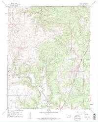
Nanos stands as a quiet rail-side settlement along the Atchison Topeka and Santa Fe railroad in Osage County at the start of the 1960s. This survey illustrates the rural landscape where the Caney and Strike Axe land divisions meet, marked by a network of drainage systems including Wild Hog Creek, Rock Creek, and Sand Mud Creek. The presence of scattered Oil Wells and a Quarry near the tracks indicates the extraction-based economy that defined much of northern Oklahoma during this era. Local history and genealogy are anchored by the Pappin Cem in the southern portion of the map and the small community of Opah. The topography is punctuated by distinctive landmarks such as Twin Mounds, which provide visual orientation across the varied terrain of hills and creek valleys.
Find a feature on this map
17 named features on this map. Tap any name to fly to it.
Don’t see what you’re looking for? This feature index may not catch every label — zoom into the map to look around manually.
Map Details
Editions of this 1960 Nanos Map
2 editions found
Other maps of this area

1906 · Nelagoney
USGS Topo · 1:24,000

1909 · Pawhuska
USGS Topo · 1:125,000

1910 · Pawhuska
USGS Topo · 1:125,000

1955 · Enid
USGS Topo · 1:250,000

1958 · Enid
USGS Topo · 1:250,000

1960 · Nelagoney
USGS Topo · 1:24,000

1960 · Herd
USGS Topo · 1:24,000

1960 · Pawhuska
USGS Topo · 1:24,000
1973 · Pearsonia
USGS Topo · 1:24,000
1973 · Pearsonia NE
USGS Topo · 1:24,000