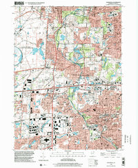
1998 Map of Naperville
USGS Topo · Published 2002About this map
Fermi National Accelerator Laboratory anchors the western edge of this landscape, representing a significant scientific footprint in the late 20th century. The West Branch DuPage River winds through a dense network of suburban development and conservation lands, including the expansive Blackwell Co For Preserv and Cantigny Park. The map documents the rapid maturation of the DuPage County corridor, where residential subdivisions are punctuated by major retail hubs like the Fox Valley Mall. Educational and civic centers are heavily detailed, from the campus of North Central College to numerous local institutions like Naperville North High Sch and Washington Jr High Sch. The presence of the Chicago and North Western railroad and the East-West Tollway illustrates the transportation infrastructure that fueled the area's growth.
Find a feature on this map
88 named features on this map. Tap any name to fly to it.
Don’t see what you’re looking for? This feature index may not catch every label — zoom into the map to look around manually.
Map Details
Editions of this 1998 Naperville Map
This is the sole edition of this map. No revisions or reprints were ever made.
Other maps of this area

1892 · Joliet
USGS Topo · 1:62,500

1908 · Wheaton
USGS Topo · 1:62,500

1923 · Joliet
USGS Topo · 1:62,500

1925 · Yorkville
USGS Topo · 1:62,500

1932 · Geneva
USGS Topo · 1:62,500

1948 · Wheaton
USGS Topo · 1:62,500

1948 · Geneva
USGS Topo · 1:62,500

1949 · Geneva
USGS Topo · 1:24,000

1950 · Aurora North
USGS Topo · 1:24,000

1953 · Naperville
USGS Topo · 1:24,000