
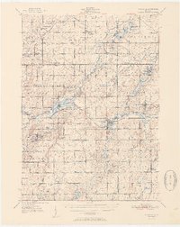
1951 Map of Nashville
USGS Topo · Published 1951About this map
Nashville and the winding Thornapple River corridor define this rural Michigan landscape as it appeared in the mid-20th century. The area is characterized by a dense network of country schools, including Quail Trap Sch, McKelvey Sch, and Barryville Sch, reflecting the community-centric organization of the townships before modern school consolidation. Along the river, Charlton Park stands as a notable landmark near the settlement of Morgan.
Find a feature on this map
78 named features on this map. Tap any name to fly to it.
Don’t see what you’re looking for? This feature index may not catch every label — zoom into the map to look around manually.
Map Details
Editions of this 1951 Nashville Map
2 editions found
Other maps of this area

1916 · Ionia
USGS Topo · 1:62,500

1918 · Battle Creek
USGS Topo · 1:62,500

1918 · Ionia
USGS Topo · 1:62,500

1918 · Galesburg
USGS Topo · 1:62,500

1918 · Lowell
USGS Topo · 1:62,500

1921 · Marshall
USGS Topo · 1:62,500

1923 · Marshall
USGS Topo · 1:62,500

1943 · Battle Creek
USGS Topo · 1:62,500

1943 · Marshall
USGS Topo · 1:62,500

1943 · Ionia
USGS Topo · 1:62,500