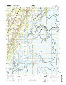
2016 Map of Nassawadox
USGS Topo · Published 2016About this map
Nassawadox and its surrounding Eastern Shore communities are defined by a complex mosaic of tidal guts, creeks, and marshes. Situated along the boundary of Accomack and Northampton counties, the landscape transitions from established inland settlements like Hare Valley and Middletown to the intricate wetlands bordering the Machipongo River. The area's agricultural and residential history is traced through family-named landmarks and small hamlets such as Marionville, Red Bank, and Little Johnsontown. To the east, the terrain dissolves into a labyrinthine network of water bodies, including Phillips Creek and The Ramshorn, which weave around features like Brickhouse Neck and Upshur Neck. This maritime interface is anchored by Webbs Island and the marshes leading out to the Atlantic Ocean, illustrating the enduring relationship between these coastal Virginia towns and the shifting shoreline of the peninsula.
Find a feature on this map
73 named features on this map. Tap any name to fly to it.
Don’t see what you’re looking for? This feature index may not catch every label — zoom into the map to look around manually.
Map Details
Editions of this 2016 Nassawadox Map
This is the sole edition of this map. No revisions or reprints were ever made.
Other maps of this area

1931 · Accomac
USGS Topo · 1:48,000

1935 · Accomac
USGS Topo · 1:62,500

1941 · Broadwater
USGS Topo · 1:62,500

1942 · Cheriton
USGS Topo · 1:24,000

1942 · Cobb Island
USGS Topo · 1:24,000

1942 · Great Machipongo Inlet
USGS Topo · 1:24,000

1942 · Little Machipongo Inlet
USGS Topo · 1:24,000

1942 · Nassawadox
USGS Topo · 1:24,000

1943 · Nassawadox
USGS Topo · 1:31,680

1943 · Jamesville
USGS Topo · 1:31,680